Lake Mead's Changing Shoreline: A 459 Meter Retreat at Callville Bay
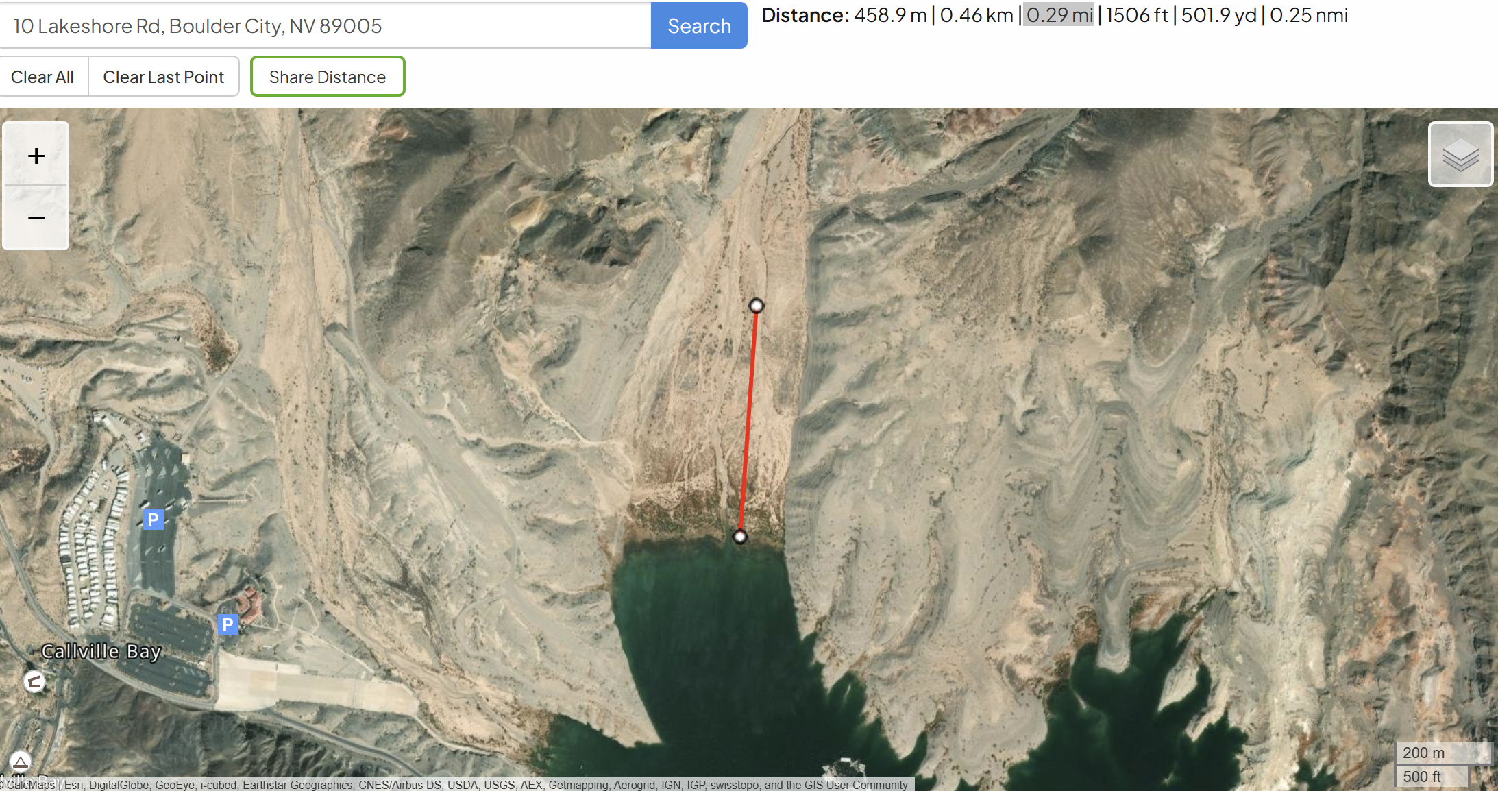
When I compared satellite images of Lake Mead from 2014 and 2026, one location immediately caught my attention. At Callville Bay, the shoreline looked dramatically different. Curious about how much had changed, I used an online mapping tool to measure the distance between the shoreline visible in the 2014 image and the shoreline in 2026. The result surprised me. At this focal point, the water's edge had retreated approximately 459 meters, or about 0.29 miles. Seeing a number attached to the visual change transformed the images from an interesting comparison into a reminder that environmental change often happens gradually enough to go unnoticed until we step back and compare the past with the present.
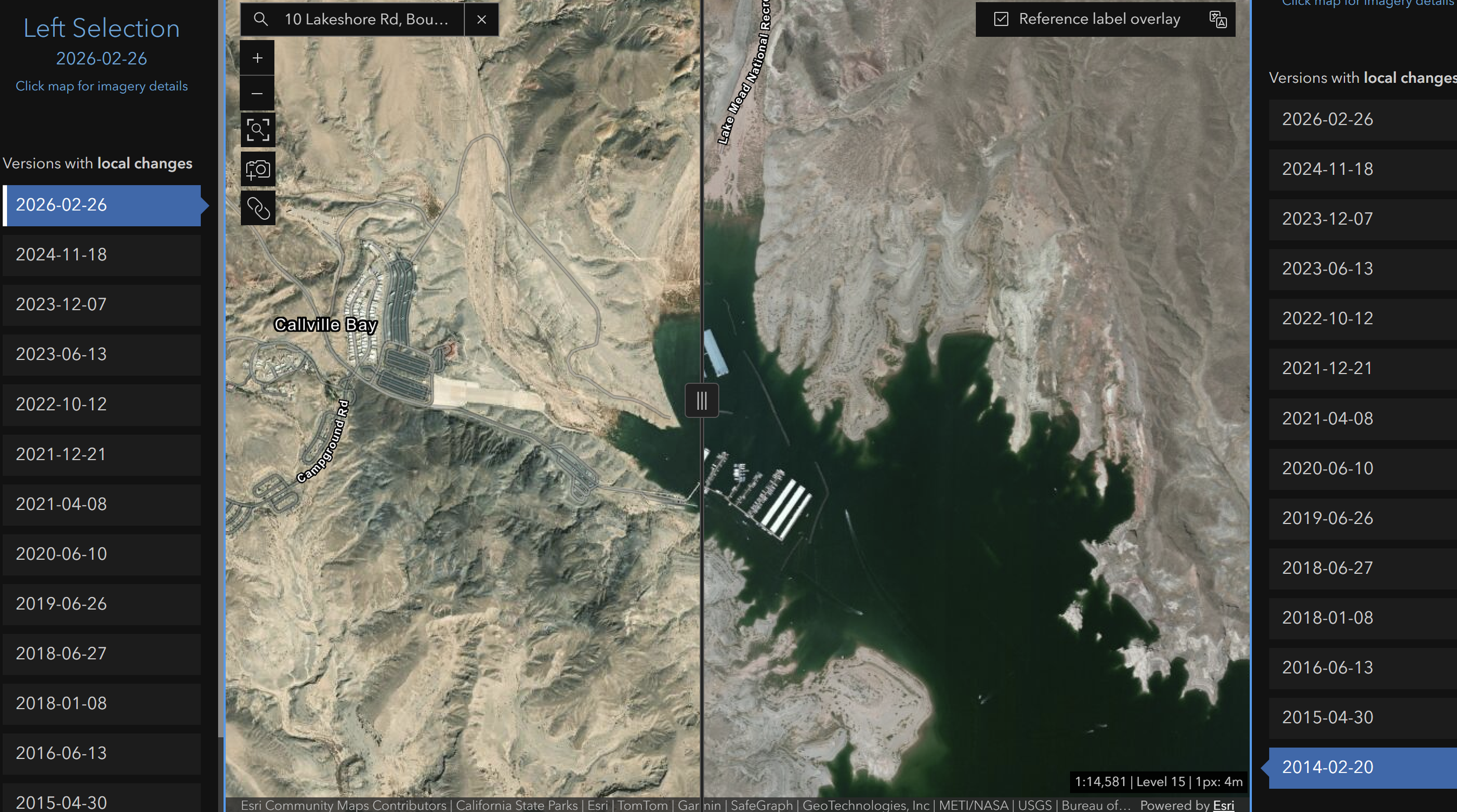
The side by side satellite images quickly show you the changes over the course of 12 years (Figure 2). In 2014, the shoreline extended much farther inland. By 2026, a wide band of exposed lakebed separated the former shoreline from the water. The second image, showing the measurement tool stretched across the exposed land, helps quantify what our eyes already recognize. Nearly half a kilometer of land that was underwater only twelve years earlier now sits exposed to the desert sun.
Lake Mead, located on the Colorado River between Nevada and Arizona, is the largest reservoir in the United States by storage capacity. Beyond its scenic beauty, the reservoir provides drinking water to approximately 25 million people, supports agriculture, generates hydroelectric power at Hoover Dam, and attracts millions of visitors each year (U.S. Bureau of Reclamation, 2025). Changes to the lake therefore affect far more than the landscape.
The retreating shoreline is the result of several factors working together. The Colorado River Basin has experienced more than two decades of persistent drought. At the same time, warmer temperatures increase evaporation while reducing mountain snowpack that feeds the Colorado River. Population growth throughout the Southwest has also increased demand for water from the same river system. Researchers describe the region as experiencing a long term megadrought, with climate change intensifying naturally dry conditions (Udall & Overpeck, 2017).
For visitors to Callville Bay, the effects are highly visible. Social media footage shows . Boat ramps must be extended or relocated. Marinas require continual adjustments. Recreation becomes more difficult as visitors walk farther to reach the water. Wildlife habitat changes as aquatic environments shrink, and lower reservoir levels reduce the amount of electricity Hoover Dam is able to generate during certain periods (U.S. Bureau of Reclamation, 2025).
Looking ahead, the trend raises important questions. If the shoreline at this location continues retreating at roughly the same rate observed between 2014 and 2026, another 459 meter retreat by 2038 would place the shoreline approximately 918 meters, or about 0.57 miles, from where it stood in 2014. Future conditions will depend on rainfall, snowpack, conservation efforts, and water management decisions. Still, the comparison demonstrates how a series of small annual changes accumulates into a dramatic transformation over little more than a decade.
The encouraging part is that people are not without options. Water conservation programs, more efficient agricultural irrigation, expanded water recycling, drought tolerant landscaping, and cooperative agreements among Colorado River Basin states all reduce pressure on the reservoir. While none of these actions alone will refill Lake Mead, together they improve the region's ability to manage water during increasingly dry conditions.
Sometimes the most effective way to understand environmental change is not through quantitative data, but by placing two satellite images beside one another and asking a simple question. What changed?
References
U.S. Bureau of Reclamation. (2025). Lake Mead water operations and reservoir information. https://www.usbr.gov/lc/region/g4000/hourly/mead-elv.html
Udall, B., & Overpeck, J. (2017). The twenty first century Colorado River hot drought and implications for the future. Water Resources Research, 53(3), 2404 to 2418. https://doi.org/10.1002/2016WR019638